Hurricane Ida Recovery Information

Hurricane Ida Recovery Information
Updated August 31, 2021
Updated September 9, 2021
For ALL EMERGENCIES AND LIFE-THREATENING SITUATIONS CALL 911
Links and other resources for Hurricane Ida Recovery
List of local Parish OHSEP offices for local Emergency Resources
DSNAP (disaster food stamps) Registration
Information about Operation Blue Roof (Free Roof Covering for Homeowners)
Community Power Stations in and Near New Orleans to Charge Your Devices While the Power is Out
Imagine Water Works has created a Community Power Map with locations where people can charge their phones and other devices in and near New Orleans. These charging stations are hosted on a volunteer basis by neighbors, organizations, and businesses, and are free to use.
Follow this link for more information about the Community Power Map and Imagine Water Works.
Prepared Foods Can Now be Purchased with Louisiana SNAP, P-EBT Benefits Due to Hurricane Ida
Follow this link for more information about Louisiana SNAP, P-EBT, and DSNAP.
211 Hurricane Ida Assistance and Shelter Information
211 connects callers to available resources 24 hours a day, seven days a week, even during disasters.
Those in need of assistance can dial 211 or text your zip code to 898-211. For shelter information, you can also dial 211 or text LASHELTER to 898-211.
Louisiana State Police Announces that All Interstate Systems in Louisiana Are Open
On August 31, 2021, Louisiana State Police announced that all interstate systems in the state are now open. Travelers are asked to use caution when driving. Most intersection traffic signals in Southeast Louisiana are not functioning; all vehicles are required to come to a stop. Please treat these areas as you would a 4-way stop sign.
Call *LSP to report hazards or reckless drivers.
The Lake Charles Convention & Visitors Bureau is providing a list of hotel and motel availabilities in Southwest Louisiana.
Follow this link to visit the page with the hotel availability list.
I-55 Northbound and Southbound Reopened in Louisiana
The Louisiana Department of Transportation and Development announced on August 31, 2021, that I-55 has reopened in both directions.
I-10 Eastbound Reopens in Louisiana August 31, 2021
The Louisiana Department of Transportation and Development has announced that I-10 eastbound is has reopened from the Texas state line to the Mississippi state line after Hurricane Ida caused multiple closures. Parts of I-10 West are still closed. Follow this link for more information.
Expected Impacts in Calcasieu Parish – Sunday/Monday (last updated August 28, 2021, 11 am)
These impacts are subject to change should the forecast track or intensity change
Wind: 30-40 MPH gust up to 50 MPH beginning Sunday between 8 pm – 11 pm; ending Monday between 6 am – 9 am
Storm Surge: None
Rainfall Totals: 2-3 inches
Tornado Threat: None
Power Outages: Isolated
A voluntary evacuation was issued for Calcasieu Parish On August 27, 2021
August 28, 2021, 10 AM Hurricane Ida Advisory
Ida is expected to begin rapidly intensifying soon.
Preparations to protect life and property should be rushed to completion today, Saturday, August 28, 2021, in the warning area along the northern gulf coast.
During the 10 am Hurricane Ida Advisory, the National Weather Service National Hurricane Center indicated that the center of Hurricane Ida was located near latitude 24.8 North, longitude 86.1 West. Ida is moving toward the northwest near 16 mph (26 km/h), and this general motion should continue through late Sunday or early Monday, followed by a slower northward motion on Monday. On the forecast track, the center of Ida will move over the southeastern Gulf of Mexico today and move over the central Gulf of Mexico tonight and early Sunday. Ida is then expected to make landfall along the U.S. northern Gulf coast within the hurricane warning area on Sunday and then move inland over portions of Louisiana or western Mississippi later on Monday.
Maximum sustained winds are near 85 mph (140 km/h) with higher gusts. Rapid strengthening is forecast during the next 24 to 36 hours and Ida is expected to be an extremely dangerous major hurricane when it approaches the northern Gulf coast on Sunday. Weakening is expected after Ida makes landfall.
Hurricane-force winds extend outward up to 30 miles (45 km) from the center and tropical-storm-force winds extend outward up to 125 miles (205 km).
The latest minimum central pressure estimated from Air Force Reserve reconnaissance aircraft data is 984 mb (29.06 inches).
Location: 24.8N 86.1W
About 350 miles South-Southeast of the mouth of the Mississippi River.
About 435 miles Southeast of Houma, Louisiana
Maximum Sustained Winds: 85 MPH
Present: Movement Northwest at 16 MPH
Minimum Central Pressure: 984 MB
Watches and Warning in Effect:
A Storm Surge Warning is in effect for:
* East of Rockefeller Wildlife Refuge Louisiana to the Mississippi/Alabama border
* Vermilion Bay, Lake Borgne, Lake Pontchartrain, and Lake Maurepas
A Hurricane Warning is in effect for:
* Intracoastal City Louisiana to the Mouth of the Pearl River
* Lake Pontchartrain, Lake Maurepas, and Metropolitan New Orleans
A Storm Surge Watch is in effect for:
* Mobile Bay
A Tropical Storm Warning is in effect for:
* Cameron Louisiana to the west of Intracoastal City Louisiana
* Mouth of the Pearl River to the Alabama/Florida border
August 27, 2021, 7 PM Hurricane Ida Advisory
During the 7 pm Hurricane Ida Advisory, the National Weather Service National Hurricane Center indicated that the center of Hurricane Ida was located over western Cuba near latitude 22.4 North, longitude 83.5 West.
Ida is moving toward the northwest near 15 mph (24 km/h), and this general motion should continue until Ida reaches the northern Gulf coast on Sunday. A slower northward motion is forecast after Ida reaches the northern Gulf Coast. On the forecast track, the center of Ida will remain over western Cuba for another hour or two and then move over the southeastern and central Gulf of Mexico later tonight and Saturday. Ida is forecast to make landfall along the U.S. northern Gulf coast within the hurricane warning area on Sunday.
Maximum sustained winds are near 80 mph (130 km/h) with higher gusts. Steady to rapid strengthening is expected when Ida moves over the southeastern and central Gulf of Mexico over the weekend, and Ida is expected to be an extremely dangerous major hurricane when it approaches the northern Gulf coast on Sunday.
Hurricane-force winds extend outward up to 25 miles (35 km) from the center and tropical-storm-force winds extend outward up to 90 miles (150 km). A wind gust to 46 mph (74 km/h) has recently been reported on Cayo Largo, Cuba.
The estimated minimum central pressure is 985 mb (29.09 inches).
August 27, 2021, 4 PM Hurricane Ida Advisory
During the 4 pm Hurricane Ida Advisory, the National Weather Service National Hurricane Center indicated that the center of Hurricane Ida was located near latitude 22.1 North, longitude 83.2 West. Ida is moving toward the northwest near 15 mph (24 km/h), and this general motion should continue until Ida reaches the northern Gulf coast on Sunday. A slower northward motion is forecast after Ida reaches the northern Gulf Coast. On the forecast track, the center of Ida will pass over western Cuba during the next several hours, and then move over the southeastern and central Gulf of Mexico later tonight and Saturday. Ida is forecast to make landfall along the U.S. northern Gulf coast within the hurricane warning area on Sunday.
Maximum sustained winds have increased to near 80 mph (130 km/h) with higher gusts. Little change in strength is anticipated while Ida moves over western Cuba this evening. Steady to rapid strengthening is expected when Ida moves over the southeastern and central Gulf of Mexico over the weekend, and Ida is expected to be an extremely dangerous major hurricane when it approaches the northern Gulf coast on Sunday.
Hurricane-force winds extend outward up to 25 miles (35 km) from the center and tropical-storm-force winds extend outward up to 90 miles (150 km). A wind gust to 46 mph (74 km/h) has recently been reported on Cayo Largo, Cuba.

Watches and warnings as of 4 pm CDT
A Storm Surge Warning is in effect for:
* East of Rockefeller Wildlife Refuge Louisiana to the
Mississippi/Alabama border
* Vermilion Bay, Lake Borgne, Lake Pontchartrain, and Lake Maurepas
A Hurricane Warning is in effect for:
* Cuban provinces of Pinar del Rio and Artemisa, and the Isle of
Youth
* Intracoastal City Louisiana to the Mouth of the Pearl River
* Lake Pontchartrain, Lake Maurepas, and Metropolitan New Orleans
A Storm Surge Watch is in effect for:
* Sabine Pass to Rockefeller Wildlife Refuge Louisiana
* Mobile Bay
A Hurricane Watch is in effect for:
* Cameron Louisiana to west of Intracoastal City Louisiana
* Mouth of the Pearl River to the Mississippi/Alabama border
A Tropical Storm Warning is in effect for:
* Cuban provinces of Matanzas, Mayabeque, and Havana
* Cameron Louisiana to west of Intracoastal City Louisiana
* Mouth of the Pearl River to the Mississippi/Alabama border
A Tropical Storm Watch is in effect for:
* Mississippi/Alabama border to the Alabama/Florida border
Southwest Louisiana Live Traffic Maps and Updates
School Cancelled in Calcasieu Parish Monday, August 30 Due to Ida
Follow this link for information about Free Sandbag Locations in Calcasieu Parish with Directions
August 27, 2021, 12:15 PM Hurricane Ida Update
In a 12:15 pm Central Time update the National Weather Service National Hurricane Center announced that Tropical Storm Ida has been upgraded to a Hurricane with maximum sustained winds estimated at 75 mph, with higher gusts.
A sustained wind of 44 mph (70 km/h) and a gust of 60 mph (96 km/h) were recently reported on Cayo Largo, Cuba.
Summary at 12:10 pm CST
Location: 21.4N 82.4W
Approximately 165 miles east of the western tip of Cuba
Maximum sustained winds of 75 MPH, moving northwest at 15 MPH, with a minimum central pressure of 987 mb.
School Cancelled in Calcasieu Parish Monday, August 30 Due to Ida
Follow this link for information about Free Sandbag Locations in Calcasieu Parish with Directions
August 27, 2021, 4 AM Tropical Storm Ida Advisory
At 4 AM CST, the NWS National Hurricane Center reported that the center of Tropical Storm Ida was located by weather radar on Grand Cayman near latitude 20.0 North, longitude 81.4 West. Ida is moving toward the northwest near 15 mph (24 km/h) and this general motion should continue over the next few days. On the forecast track, the center of Ida will move away from the Cayman Islands this morning, pass near or over the Isle of Youth and western Cuba later today, and over the southeastern and central Gulf of Mexico tonight and Saturday. The system is forecast to approach the U.S. northern Gulf Coast on Sunday.
Maximum sustained winds have increased to near 45 mph (75 km/h) with higher gusts, and additional steady to rapid strengthening is expected during the next few days. Ida is forecast to become a hurricane over the southeastern Gulf of Mexico in a day or two and to be at or near major hurricane strength when it approaches the northern Gulf Coast.
Tropical-storm-force winds extend outward up to 80 miles (130 km) from the center.
The estimated minimum central pressure is 1001 mb (29.56 inches). Grand Cayman Island recently reported a pressure of 1003 mb (29.62 inches).
A Storm Surge Watch is in effect for:
* Sabine Pass to Alabama/Florida border
* Vermilion Bay, Lake Borgne, Lake Pontchartrain, Lake Maurepas, and Mobile Bay
A Hurricane Watch is in effect for:
* Cameron, Louisiana to the Mississippi/Alabama border
* Lake Pontchartrain, Lake Maurepas, and Metropolitan New Orleans
A Tropical Storm Warning is in effect for:
* Cayman Islands
* Cuban provinces of Matanzas, Mayabeque, Havana, Artemisa, Pinar del Rio, and the Isle of Youth
A Tropical Storm Watch is in effect for:
* Mississippi/Alabama border to the Alabama/Florida border.
Follow this link for information about Free Sandbag Locations in Calcasieu Parish with Directions
August 26, 2021, 10 PM Tropical Storm Ida Advisory
At 10 pm Central Time, Tropical Storm Ida was located 18.6N 80.5W, approximately 365 miles southeast of the Western tip of Cuba.
Maximum sustained winds were measured at.40 MPH, with the storm moving northwest at 12 MPH and a minimum pressure of 1006 MB.
The following changes, watches, and warnings were issued by the NWS National Hurricane Center in the 10 pm CT update.
A Storm Surge Watch has been issued from Sabine Pass to the Alabama/Florida border including Vermilion Bay, Lake Borgne, Lake Pontchartrain, Lake Maurepas, and Mobile Bay
A Hurricane Watch has been issued from Cameron, Louisiana eastward
to the Mississippi/Alabama border, including Lake Pontchartrain,
Lake Maurepas, and metropolitan New Orleans.
A Tropical Storm Watch has been issued from the Mississippi/Alabama border to the Alabama/Florida border.
A Storm Surge Watch is in effect for:
* Sabine Pass to Alabama/Florida border
* Vermilion Bay, Lake Borgne, Lake Pontchartrain, Lake Maurepas, and Mobile Bay
A Hurricane Watch is in effect for:
* Cameron, Louisiana to the Mississippi/Alabama border
* Lake Pontchartrain, Lake Maurepas, and Metropolitan New Orleans
A Tropical Storm Warning is in effect for:
* Cayman Islands
* Cuban provinces of Matanzas, Mayabeque, Havana, Artemisa, Pinar del Rio, and the Isle of Youth
A Tropical Storm Watch is in effect for…
* Mississippi/Alabama border to the Alabama/Florida border.
A Storm Surge Watch means there is a possibility of life-threatening inundation, from rising water moving inland from the coastline, in the indicated locations during the next 48 hours.
A Hurricane Watch means that hurricane conditions are possible within the watch area. A watch is typically issued 48 hours before the anticipated first occurrence of tropical-storm-force winds, conditions that make outside preparations difficult or dangerous.
A Tropical Storm Warning means that tropical storm conditions are expected somewhere within the warning area within 36 hours.
A Tropical Storm Watch means that tropical storm conditions are possible within the watch area, generally within 48 hours.
Interests elsewhere in central and western Cuba, in the northern Yucatan Peninsula, and elsewhere along the northern U.S. Gulf coast should monitor the progress of this system.
August 26, 2021, 7 PM Tropical Storm Ida Advisory

Click or tap image to enlarge.
On Thursday, August 26, 2021, at 7 pm Central Time, the NWS National Hurricane Center released an updated tropical weather outlook on recently
upgraded Tropical Storm Ida, located over the northwestern Caribbean Sea, near the Gulf of Mexico.
At 8 pm Eastern Time (7 pm Central time), the center of Tropical Storm Ida was located near latitude 18.0 North, longitude 80.1 West. The storm is moving toward the northwest near 13 mph (20 km/h), and this general motion should continue over the next few days. On the forecast track, the center of Ida will pass near or over the Cayman Islands tonight, the Isle of Youth and western Cuba Friday, and over the southeastern and central Gulf of Mexico Friday night and Saturday. The system is forecast to approach the U.S. northern Gulf Coast on Sunday.
Maximum sustained winds are near 40 mph (65 km/h) with higher gusts. Steady strengthening is forecast during the next few days. Ida is forecast to become a hurricane when it is near western Cuba with additional strengthening expected while it moves over the Gulf of Mexico. Ida could be near major hurricane strength when it approaches the northern Gulf Coast.
Tropical-storm-force winds extend outward up to 70 miles (110 km) north of the center.
Tropical Depression Formation Likely, Movement into the Gulf of Mexico Possible by August 29
This section originally published on August 25, 2021
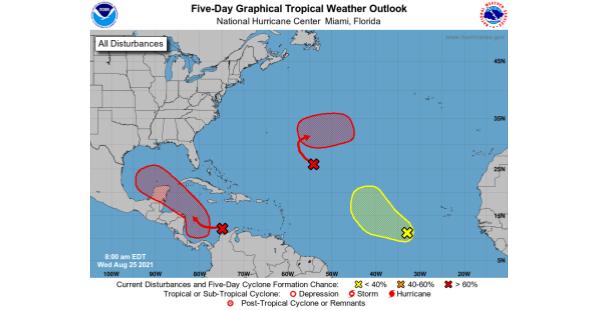
The NWS National Hurricane Center released a tropical weather outlook on August 25, 2021, indicating an 80% chance of storm formation in the Gulf of Mexico over the next 5 days.
From the National Weather Service, National Hurricane Center – A broad area of low pressure is expected to form over the southwestern Caribbean Sea during the next day or so from a tropical wave currently located over northwestern Colombia and the south-central Caribbean Sea. Environmental conditions are forecast to be conducive for development, and a tropical depression is likely to form late this week or over the weekend while the system moves west-northwestward to northwestward over the northwestern Caribbean Sea. The disturbance is expected to move near or across the Yucatan Peninsula of Mexico on Saturday and move into the western Gulf of Mexico by Sunday where conditions could be favorable for additional development to occur.
Formation chance through 48 hours (8 am, Friday, August 27, 2021) medium, 40 percent.
Formation chance through 5 days (8 am, Monday, August 30, 2021) high, 80 percent.
Outlook from National Weather Service Forecaster Stewart.
Vinton I-10 Westbound Right Lane Closure Scheduled March 31-April 1
Vinton, Louisiana – The Louisiana Department of Transportation and Development has announced an overnight lane closure on Interstate 10 westbound in Vinton for roadway maintenance. According to the agency, the right lane of I-10 westbound will be closed from Coone…
Lake Charles And Westlake I-10 Shoulder Closures Scheduled Through April 22, 2026
LAKE CHARLES, La. — The Louisiana Department of Transportation and Development has announced multiple singular shoulder closures along Interstate 10 in both directions between mile marker 25 in Westlake and mile marker 31 in Lake Charles from Sunday, March 22, 2026,…
Sulphur Drivers Advised Of March 16-20 Lane Closures At Beglis Pkwy Intersection
SULPHUR, LA. — The Louisiana Department of Transportation and Development, or DOTD, said alternating lane closures are scheduled to begin Monday, March 16, 2026, at the intersection of E Burton Street and North Beglis Parkway in Sulphur as crews perform milling and…