Nicholas Downgraded to Tropical Depression, Heavy Rainfall Possible Across Portions of the Deep South

Nicholas Downgraded to Tropical Depression, Heavy Rainfall Possible Across Portions of the Deep South
Published September 12, 2021
Updated September 14, 2021
September 24 at 7 pm, Tropical Depression Nicholas was located near East Bay in Texas, just east of Smith Point, Texas, and just south of Double Bayou, Texas, and is moving east-northeast near 6 mph. The Tropical Storm Warning has been discontinued for the coasts of Texas and Louisiana, though life-threatening flash floods are still possible across the portions of the deep south during the next couple of days.
Tuesday, September 14, 2021, 7 pm Tropical Depression Nicholas Advisory
The National Weather Service National Hurricane Center downgraded Hurricane Nicholas to a Tropical Depression during the 7 pm advisory. The Tropical Storm Warning has been discontinued for the coasts of Texas and Louisiana, though life-threatening flash floods are still possible across the portions of the deep south during the next couple of days.
At 7 pm the center of Tropical Depression Nicholas was located by Doppler radars, satellites, and surface observations near East Bay just east of Smith Point, Texas, and just south of Double Bayou, Texas. Nicholas is moving toward the east-northeast near 6 mph (9 km/h) and this general motion should continue through tonight. An eastward turn is expected over Louisiana on Wednesday. Little motion is anticipated on Thursday.
NOAA Doppler weather radar and surface observations indicate that maximum sustained winds have decreased to near 35 mph (55 km/h) with higher gusts. Continued gradual weakening is expected during the next couple of days, and Tropical Depression Nicholas is forecast to degenerate into a remnant low on Wednesday or by early Thursday.
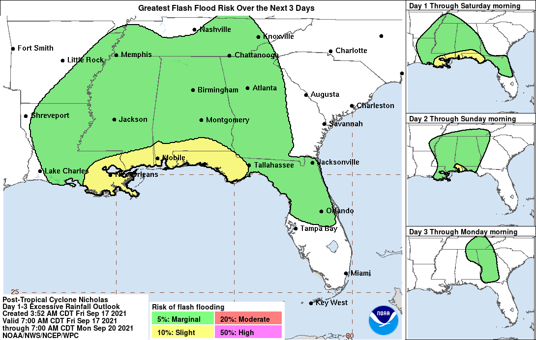
Tropical Depression Nicholas is expected to produce additional rainfall amounts of 5 to 10 inches across portions of southern and central Louisiana, southern Mississippi, far southern Alabama, and the western Florida Panhandle through early Friday, with isolated storm totals of 20 inches possible from southern Louisiana to the far western Florida Panhandle. Life-threatening flash flooding impacts, especially in urban areas, are possible across these regions.
Widespread minor to isolated moderate river flooding is expected across portions of the upper Texas Gulf Coast and southern Louisiana and Mississippi.
Visit our weather page for current weather conditions and forecasts for Southwest Louisiana.
Free Sandbag Locations in Calcasieu Parish

Monday, September 13, 2021, 10 pm Hurricane Nicholas Advisory
The National Weather Service National Hurricane Center upgraded Tropical Storm Nicholas to a hurricane during the 10 pm advisory.
The center of Hurricane Nicholas was located near latitude 28.4 North, longitude 95.8 West. Nicholas is moving toward the north-northeast near 10 mph (17 km/h) and this general motion is expected to continue through tonight, followed by a turn toward the northeast and a slower motion by late Tuesday and an even slower eastward motion on Wednesday. On the forecast track, the center of Nicholas is expected to make landfall along the Texas coast in a few hours, move over extreme Southeastern Texas on Tuesday and early Wednesday, and over Southwestern Louisiana later on Wednesday.
Maximum sustained winds are near 75 mph (120 km/h) with 95 mph gusts. Little change in strength is likely before landfall, followed by weakening after the center moves inland.
Hurricane-force winds extend outward up to 25 miles (35 km) from the center and tropical-storm-force winds extend outward up to 115 miles (185 km). A Weatherflow station at Matagorda Bay recently reported a 1-minute sustained wind of 76 mph (122 km/h) gusting to 95 mph (153 km/h).
Nicholas is expected to produce storm total rainfall of 6 to 12 inches, with isolated maximum amounts of 18 inches, across the upper Texas coastal areas into Wednesday. Life-threatening flash flooding impacts, especially in urbanized metropolitan areas, are possible across portions of the upper Texas Gulf Coast into far Southwestern Louisiana.
Across interior southeast Texas into southern-central Louisiana and southern Mississippi, rainfall totals of 4 to 8 inches with locally higher amounts near 10 inches are expected into Thursday. This rainfall may produce areas of considerable flash and urban flooding.
The potential for minor to isolated major river flooding exists across the entire region especially in smaller river basins and urban areas.
A tornado or two will be possible through Tuesday morning along the upper Texas and Southwest Louisiana coast.
Key Messages from the National Weather Service National Hurricane Center as of 10 pm, September 13, 2021
1. Heavy rainfall will impact portions of southeastern Texas, Louisiana, and southern Mississippi through the middle of the week. Significant rainfall amounts are expected, potentially resulting in areas of life-threatening flash and urban flooding, along the eastern Texas coast into southwestern Louisiana. Minor to isolated major river flooding is also possible in smaller river basins and urban areas.
2. There is the danger of life-threatening storm surge inundation along the coast of Texas from Port Aransas to Sabine Pass. Residents in these areas should follow any advice given by local officials.
3. Hurricane conditions are expected within the Hurricane Warning area and Tropical storm conditions are expected with the Tropical Storm Warning area along the Texas coast.
Monday, September 13, 2021, 5 pm Advisory from Calcasieu Parish Officials
Local authorities have announced that they will have highwater rescue vehicles throughout Calcasieu Parish. Drivers are advised to not drive through high waters and to stay off the roadways if possible during the storm. Calcasieu Parish Schools, SOWELA, and McNeese will remain closed on September 14, 2021.
Monday, September 13, 2021, 4 pm Central Time Advisory
The National Weather Service National Hurricane Center reported at 4:00 Central Time that the center of Tropical Storm Nicholas was located by NOAA Doppler weather radars near latitude 27.4 North, longitude 96.4 West. Nicholas is moving toward the north-northeast near 12 mph (19 km/h) and this general motion is expected to continue through tonight, followed by a turn toward the northeast by late Tuesday. On the forecast track, the center of Nicholas is expected to make landfall along the central Texas coast later tonight. Significant rainfall in Southwest Louisiana is now expected starting Tuesday, September 14, 2021.
Nicholas is expected to produce storm total rainfall of 6 to 12 inches, with isolated maximum amounts of 18 inches, across portions of the middle and upper Texas coastal areas through Wednesday. Life-threatening flash flooding impacts, especially in highly urbanized metropolitan areas, are possible across portions of the upper Texas Gulf Coast and far Southwestern Louisiana.
Across interior southeast Texas into southern-central Louisiana and southern Mississippi, rainfall totals of 4 to 8 inches with locally higher amounts near 10 inches are expected through Thursday. This rainfall may produce areas of considerable flash and urban flooding.
The potential for minor to isolated moderate river flooding exists across the entire region, along with isolated major river flooding, especially in the smaller river basins and urban areas.
Key Messages from the National Weather Service National Hurricane Center as of 4 pm, September 13, 2021
1. Heavy rainfall will impact portions of southeastern Texas, Louisiana, and southern Mississippi through the middle of the week. Significant rainfall amounts are possible, potentially resulting in areas of life-threatening flash and urban flooding, especially in highly urbanized metropolitan areas. Minor to isolated moderate river flooding is also expected, along with isolated major river flooding across smaller river basins and urban areas.
2. There is the danger of life-threatening storm surge inundation along the coast of Texas from Port Aransas to Sabine Pass. Residents in these areas should follow any advice given by local officials.
3. Nicholas is forecast to approach the middle Texas coast as a strong tropical storm this evening, September 13, 2021, and could be near hurricane intensity at landfall. Tropical storm conditions are expected along portions of the middle and upper Texas coasts this evening and tonight, with hurricane conditions possible from Port Aransas to San Luis Pass.
Sunday, September 12, 2021, 1 pm Central Time Advisory
Calcasieu Parish Schools Closed September 13 Due to Threat of Flooding from Tropical Storm Nicholas
The National Weather Service National Hurricane Center reported at 1:00 Central Time, that Tropical Storm Nicholas is moving toward the north-northwest near 15 mph (24 km/h). Satellite and reconnaissance aircraft data suggest that the center may be re-forming farther north. As a result, some erratic motion is possible this afternoon, but a general north-northwestward motion near 15 mph (24 km/h) should resume later today. This motion should then continue through tonight. A slower northward or north-northeastward motion is forecast by late Monday or Monday night. On the forecast track, the center of Nicholas will pass near or just offshore the coasts of northeastern Mexico and South Texas late Monday, and approach the south or central Texas coast Monday night or early Tuesday.
The center of Tropical Storm Nicholas was near latitude 21.7 North, longitude 95.5 West.
Nicholas is expected to produce storm total rainfall of 5 to 10 inches, with isolated maximum amounts of 15 inches, across portions of coastal Texas into southwest Louisiana today through the middle of the week. This rainfall may produce areas of flash, urban, and isolated river flooding.
Maximum sustained winds are near 40 mph (65 km/h) with higher gusts. Gradual strengthening is forecast while Nicholas approaches the northwestern Gulf coast during the next day or so.
Tropical-storm-force winds extend outward up to 105 miles (165 km) from the center.
The estimated minimum central pressure is 1008 mb (29.77 inches).
Sunday, September 12, 2021, 10 am Central Time Advisory
On Saturday, September 12, 2021, during the 10:30 am advisory, the National Weather Service in Lake Charles indicated that Tropical Storm Nicholas is now expected to begin moving over Southwest Louisiana and Southeast Texas starting late Sunday, September 12. Storms in this system may produce 5-10 inches of rain, and up to 20-25 inches in some areas. Heavy rainfall is expected to begin Monday, September 13, and continue until late Wednesday, September 15, or early Thursday, September 16.
If Tropical Storm Nicholas remains west, partially over land, it may be mostly rain. If it moves east to remain over the Gulf of Mexico longer, winds may continue to strengthen, and there is a potential that this becomes a hurricane. Though as of Sunday, November 12, 2021, this is currently expected to be mostly a rainfall event in the Lake Charles area with wind gusts in the 25mph-35mph range.
Saturday, September 11, 2021, 6 pm Central Time Advisory
On Saturday, September 11, 2021, during the 6 pm advisory, the National Weather Service in Lake Charles indicated that this storm system is expected to possibly move over Southwest Louisiana and Southeast Texas on Tuesday, September 14. Storms in this system may produce 10-15 inches of rain, and up to 20 inches in some areas. Heavy rainfall is expected to continue until Thursday, September 16.
If the storm remains over the Gulf of Mexico longer, strong winds up to hurricane strength are also possible.
Saturday, September 11, 2021, 1 pm Central Time Advisory
The National Weather Service National Hurricane Center has reported that a tropical wave and an upper-level trough continue to produce a large area of disorganized showers and thunderstorms over portions of southeastern Mexico and the southern and central Gulf of Mexico. Although upper-level winds are not conducive for development currently, they are expected to become more favorable for the system during the next day or so. A tropical depression is likely to form on Sunday or Monday while the disturbance moves northwestward and then northward near the coast of northeastern Mexico. Further development will be possible through the middle of next week if it remains over water, and interests along the western and northwestern Gulf coast should monitor the progress of this system. An Air Force Hurricane Hunter aircraft is scheduled to investigate the system tomorrow.
Regardless of development, this disturbance is expected to produce heavy rain across portions of Central America and the Yucatan Peninsula through today which may lead to flash flooding and mudslides. By late this weekend, heavy rain will likely reach portions of the western Gulf Coast, including coastal Texas and Louisiana through the middle of next week. Localized significant rainfall amounts will be possible, potentially resulting in areas of flash and urban flooding.
- Formation chance through 48 hours (Monday, September 13, 2021) is high, at 80 percent.
- Formation chance through 5 days (Thursday, September 16, 2021) is high, at 90 percent.

Vinton I-10 Westbound Right Lane Closure Scheduled March 31-April 1
Vinton, Louisiana – The Louisiana Department of Transportation and Development has announced an overnight lane closure on Interstate 10 westbound in Vinton for roadway maintenance. According to the agency, the right lane of I-10 westbound will be closed from Coone…
Lake Charles And Westlake I-10 Shoulder Closures Scheduled Through April 22, 2026
LAKE CHARLES, La. — The Louisiana Department of Transportation and Development has announced multiple singular shoulder closures along Interstate 10 in both directions between mile marker 25 in Westlake and mile marker 31 in Lake Charles from Sunday, March 22, 2026,…
Sulphur Drivers Advised Of March 16-20 Lane Closures At Beglis Pkwy Intersection
SULPHUR, LA. — The Louisiana Department of Transportation and Development, or DOTD, said alternating lane closures are scheduled to begin Monday, March 16, 2026, at the intersection of E Burton Street and North Beglis Parkway in Sulphur as crews perform milling and…