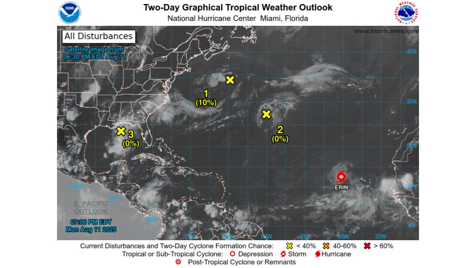
Louisiana – The National Hurricane Center (NHC) is issuing advisories on Tropical Storm Erin in the eastern tropical Atlantic, while also monitoring a weak trough in the northeastern Gulf that could bring locally heavy rain to parts of the central Gulf Coast, including Louisiana, through Tuesday.
Key points:
- Tropical Storm Erin is located several hundred miles west of the Cabo Verde Islands in the eastern tropical Atlantic, with the NHC continuing advisories as the storm tracks west to northwest over the open ocean.
- A non-tropical low a few hundred miles south-southeast of Nova Scotia may see limited tropical or subtropical development near the Gulf Stream over the next one to two days before moving over cooler waters midweek, curbing further development; formation chances are 10 percent through 48 hours and seven days.
- A weak surface trough in the central Atlantic is producing scattered, disorganized showers with no expected development; formation chances are near 0 percent through 48 hours and seven days.
- In the northeastern Gulf, a surface trough is generating a broad area of disorganized showers and thunderstorms; development is not anticipated before it moves inland Tuesday, but locally heavy rainfall could cause flash flooding across the Florida Panhandle, southern Alabama, southern Mississippi, and southeastern Louisiana over the next day or so.
- For rainfall hazards and localized forecasts, residents should check products from local National Weather Service offices.
Tropical Storm Erin
- Location and status: Erin is over the eastern tropical Atlantic, several hundred miles west of the Cabo Verde Islands, with NHC advisories active as the storm organizes in a favorable environment for gradual strengthening.
- Outlook: Forecast discussions from national outlets indicate Erin could strengthen as it moves across warmer waters with generally supportive upper-level winds, though any U.S. impacts remain uncertain and are not currently forecast in the near term.
Northwestern Atlantic low near the Gulf Stream
- Setup: A non-tropical low south-southeast of Nova Scotia is producing disorganized showers and storms west of its center.
- Development odds: Tropical or subtropical formation is limited to 10 percent through 48 hours and seven days as the low drifts west near the warm Gulf Stream, then turns north over cooler waters by midweek, ending prospects for development.
Central Atlantic disturbance
- A weak surface trough interacting with an upper-level disturbance is causing scattered, disorganized showers; there is no expected development as it drifts generally north over the next day or two, with near 0 percent odds through 48 hours and seven days.
Northeastern Gulf trough and rainfall threat
- A surface trough in the north-central Gulf is tied to a broad area of disorganized showers and storms.
- Development: Not anticipated before the system moves inland Tuesday; formation chances are near 0 percent through 48 hours and seven days.
- Hazards: Locally heavy rainfall could lead to flash flooding from the Florida Panhandle to southeastern Louisiana during the next day or so. The NHC advises monitoring local NWS products for flood watches, warnings, and rainfall forecasts.
What this means for Louisiana
- Southeastern Louisiana could see periods of heavy rain and possible flash flooding as the Gulf trough moves inland on Tuesday, even though tropical development is not expected.
- Residents should stay weather-aware and review local flood guidance, especially in low-lying and poor-drainage areas.
Two-Day Graphical Tropical Weather Outlook

Seven-Day Graphical Tropical Weather Outlook

