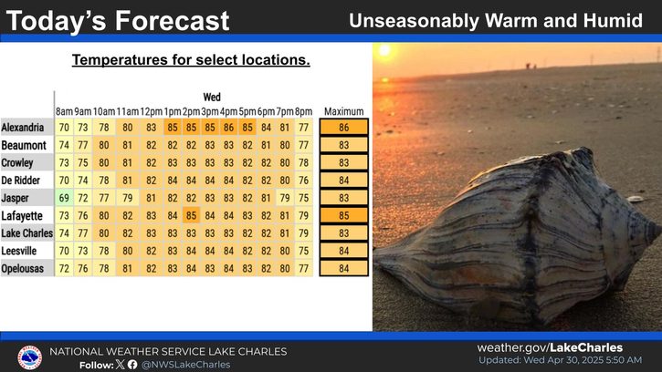
Lake Charles, Louisiana - As the region braces for an influx of arctic air, forecasters are continuing to predict that temperatures will plummet starting Sunday night and may remain below freezing through at least Wednesday night. This weather pattern is expected to bring hard freeze conditions and dangerous wind chills, prompting officials to issue information for residents in southeast Texas and parts of central and southwest Louisiana.
Meteorologists have high confidence in the temperature forecasts, which indicate subfreezing highs and lows for several days. Preliminary forecasts for Lake Charles, Louisiana, show temperatures dipping to 29°F on Monday morning, with afternoon highs reaching only 37-40°F. Tuesday morning could see even colder temperatures, with a low of 28°F before a modest recovery in the afternoon. On Wednesday and Thursday, morning lows are expected to hover around 30°F, with afternoon temperatures slightly increasing but still remaining chilly.
Wind chills are a significant concern during this period, as they can make the air feel even colder. For Lake Charles, wind chills are projected to plunge to 19°F early Monday morning, rising slightly throughout the day. Tuesday morning could see wind chills as low as 14°F, with a gradual improvement expected by mid-morning and into the afternoon. Wind chill values are forecasted to remain in the low 20s°F on Wednesday and Thursday, making it essential for residents to dress warmly and limit exposure to the cold.
While the temperature forecast is relatively stable, the potential for winter precipitation remains uncertain. Rain, snow, or freezing rain could develop as a result of a Gulf low pressure system; however, the strength and track of this weather system, along with the moisture it might bring, are still unclear. Meteorologists caution that the depth of the cold air and the timing of the moisture will play crucial roles in determining whether winter precipitation will impact the region.
At this time, it is too early to assess the possible effects of any winter precipitation, including accumulated snow or ice, on local infrastructure and safety. Residents are advised to stay informed through weather updates as conditions develop in the coming days.
As the cold front approaches, it is important for residents to prepare for the potential impacts of severe winter weather. This includes ensuring adequate heating in homes, providing shelter for vulnerable populations, and being cautious when traveling in icy conditions.